Cardross Copper Project
The Cardross mineralisation was discovered in 1898 and was intermittently worked from a number of mine shafts until 1939. Historical production is reported at 24,000 t grading at 8.4% Cu, 2.9g/t Au and 113g/t Ag, yielding 2,000t of copper, 68 kg of gold and 2,700 kg of silver. Mineralisation is open at depth and along strike. Most of the historical production came from the Chieftain Mine.
Cardross has previously been a significant producer of copper and gold; mostly from onsite smelting and then from trucking to Mungana. Several early assessments have looked at extensions to the underground workings, especially the Chieftain Mine.
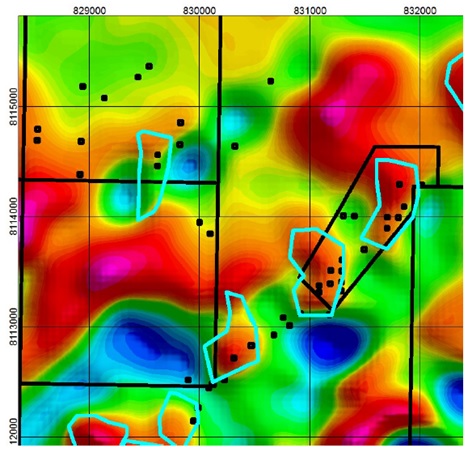
Cardross IP showing IP trend and earlier drilling by Axiom Mining (see Axiom Mining ASX announcement dated 6 August 2012)
Recent geophysical interpretation by Tartana has identified discrete magnetic highs associated with mineralisation.
The mineralisation at Cardross copper, occurring as sulphide lodes, tends to be associated with clay, sericite and chlorite alteration, the latter being closely associated with the mineralised lodes. The mineralisation is associated with the northeast-trending, west-dipping Cardross Shear Zone which has been mapped over a distance of more than 6 km. Observations suggest that the Cardross Shear Zone consists of multiple faults within a zone varying between 20 m and 100 m wide, and multiple en echelon zones of mineralisation have developed within the shear zone (Axiom, 2006).
Key drilling results from 2006 and 2007 are presented below with additional results reported in 2012 (Axiom ASX Announcement 6 August 2012) including:
- CA12RC06 - 11 m grading at 2.68% Cu, 0.12 g/t Au and 47.5 g/t Ag from 38 m
– Including 1 m grading at 8.41% Cu, 0.54 g/t Au and 161 g/t Ag from 44 m
- CA12RC07 - 5 m grading at 1.11% Cu, 0.31 g/t Au and 9.05 g/t Ag from 44 m
Additional RC drilling by Axiom confirmed a continuation of mineralisation to the north within the project area, with three of five RC holes intersecting copper-gold-silver mineralisation hosted in a massive sulphide zone.
Results included:
- CA12RC01 - 7 m grading at 1.15% Cu, 0.65 g/t Au and 16.3 g/t Ag from 77 m
– Including 2 m grading at 2.33% Cu, 0.85 g/t Au from 88 m
- CA12RC01 - 3 m grading at 0.70% Cu, 0.76 g/t Au and 9.4 g/t Ag from 91 m
- CA12RC03 - 4 m grading at 0.99% Cu from 49 m
- CAR12C04 - 4 m grading at 0.69% Cu, 0.55 g/t Au and 10.3 g/t Ag from 85 m.
Our approach is different to previous explorers which have tended to focus on the northeast trending Cardross shear zone.
Historical reference outlines that the mineralisation is associated with cross-cutting felsic dykes. This changes the approach to exploration which will focus on the intersection of the cross-cutting mineralised dykes and the Cardross shear zone.
‘There are several belts of mineralisation, and the trend of these and of the individual lodes is about north-east and south-west. The elvans*, though having a trend at right angles to the lode direction, are evidently closely connected with the orebodies, since in proximity to the dyke the lode is aways richer, while in the absence of dykes the lodes are often barren. This relationship coupled with the fact that the dykes often carry sulphides in workable amount, leads the author to the conclusion that the metalliferous solutions were introduced along the dyke fissures.
*A Cornish mining term for dyke rocks of granitic composition containing phenocrysts of quartz and orthoclase with tourmaline occurring as isolated crystals and radiating groups.
The Arbouin Copper Mines at Cardross by L.C. Ball. Queensland Geological Survey, Publication No. 261. pp 69. Brisbane, 1918